|
|
 |
|
Calanoida ( Order ) |
|
|
|
Clausocalanoidea ( Superfamily ) |
|
|
|
Clausocalanidae ( Family ) |
|
|
|
Drepanopus ( Genus ) |
|
|
| |
Drepanopus bispinosus Bayly, 1982 (F,M) | |
| | | | | | | Ref.: | | | Bayly, 1982 (p.165, figs.F,M); | 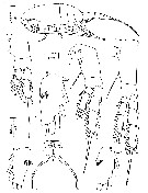 issued from : I.A.E. Bayly in Aust. J. Mar. Freshw. Res., 1982, 33. [p.166, Fig. 2]. Female (from Burton Lake, Antarctica): a, habitus (lateral); b, P1; c, P2; d, P4; e, P5; f-h, endopods of P1 (showing details of spinule patch).
|
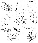 issued from : I.A.E. Bayly in Aust. J. Mar. Freshw. Res., 1982, 33. [p.167, Fig. 3]. Female: d, Mxp; e, A2. Male: a, P5 (posterior view); b, left A1 (segments 17-23); c, right A1 (segments 17-22); f, Mx2.
|
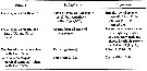 issued from : I.A.E. Bayly in Aust. J. Mar. Freshw. Res., 1982, 33. [p.169, Table 2]. Discrimination of D. bispinosus and D. pectinatus.
| | | | | Compl. Ref.: | | | Tucker & Burton, 1990 (p.591, tab.1, Rem.: seasonal, spatial variations); Eslake & al., 1991 (p.93, Table 1, 2, temporal changes); Wang, 1991 (p.613, ecophysiology, sex ratio); 1992 (p.151, population dynamicMauchline, 1998 (tab.58); Razouls & al., 2000 (p.343, tab. 2, 5, Appendix); Park & Ferrari, 2009 (p.143, Table 1, fig.2, Appendix 1, biogeography) | | | | NZ: | 1 | | |
|
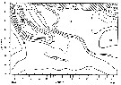
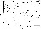
Distribution map of Drepanopus bispinosus by geographical zones
|
| | | | | | 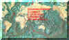 Chart of 1996 Chart of 1996 | |
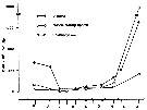
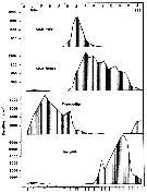 Issued from : Z. Wang in Proc. NIPR Sympos. Polar Biol., 1992, N°5. [p.156, Fig.6]. Issued from : Z. Wang in Proc. NIPR Sympos. Polar Biol., 1992, N°5. [p.156, Fig.6].
Monthly variations of poulation densities of D. bispinosus in Burton Lake near Davis, Antarctica (Dec. 1983-Jan. 1985).
Arrows indicate sampling dates. |
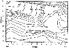
 Issued from : Z. Wang in Proc. NIPR Sympos. Polar Biol., 1992, N°5. [p.153, Fig.2]. Issued from : Z. Wang in Proc. NIPR Sympos. Polar Biol., 1992, N°5. [p.153, Fig.2].
Isothermes (°C) in Burton Lake, Antarctica, during 1984.
Arrows indicate sampling dates. |
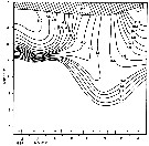
 Issued from : Z. Wang in Proc. NIPR Sympos. Polar Biol., 1992, N°5. [p.154, Fig.3]. Issued from : Z. Wang in Proc. NIPR Sympos. Polar Biol., 1992, N°5. [p.154, Fig.3].
Isohaline (°/00) map of Burton Lake, Antarctica, during 1984.
Arrows indicate sampling dates. |
 Issued from : Z. Wang in Proc. NIPR Sympos. Polar Biol., 1992, N°5. [p.154, Fig.4]. Issued from : Z. Wang in Proc. NIPR Sympos. Polar Biol., 1992, N°5. [p.154, Fig.4].
Profiles of oxygen content (ml/l) in Burton Lake, Antarctica, during 1984.
Arrows indicate sampling dates. |
 Issued from : Z. Wang in Proc. NIPR Sympos. Polar Biol., 1992, N°5. [p.155, Fig.5]. Issued from : Z. Wang in Proc. NIPR Sympos. Polar Biol., 1992, N°5. [p.155, Fig.5].
Profiles of pH in Burton Lake, Antarctica, during 1984.
Arrows indicate sampling dates. |
 Issued from : Z. Wang in Proc. NIPR Sympos. Polar Biol., 1992, N°5. [p.158, Fig.8]. Issued from : Z. Wang in Proc. NIPR Sympos. Polar Biol., 1992, N°5. [p.158, Fig.8].
Seasonal variations of some phytoplankton densities in Burton Lake, Antarctica (May 1984-January 1985). |
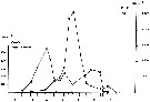 Issued from : Z. Wang in Proc. NIPR Sympos. Polar Biol., 1992, N°5. [p.157, Fig.7]. Issued from : Z. Wang in Proc. NIPR Sympos. Polar Biol., 1992, N°5. [p.157, Fig.7].
Monthly variations of density of ovigerous female and egg of D. bispinosus in Burton Lake, Antarctica, in 1984.
Arrows indicate sampling dates. |
 Issued from : E.T. Park & F.D. Ferrari in A selection from Smithsonian at the Poles Contributions to International Polar year. I. Krupnik, M.A. Lang and S.E. Miller, eds., Publs. by Smithsonian Institution Scholarly Press, Washington DC., 2009. [p.167, Fig.2]. Issued from : E.T. Park & F.D. Ferrari in A selection from Smithsonian at the Poles Contributions to International Polar year. I. Krupnik, M.A. Lang and S.E. Miller, eds., Publs. by Smithsonian Institution Scholarly Press, Washington DC., 2009. [p.167, Fig.2].
Distribution of selected pelagic calanoids Drepanopus bispinosus of the Southern Ocean and the closest relative in the subarctic region of the Arctic Ocean. |
| | | | Loc: | | | Antarct. (Indian: Vestfold Hills, Fletcher Lake, Burton Lake, Station Davis-Gardner Is.) | | | | N: | 5 | | | | Lg.: | | | (375) F: 2,8-2,23; M: 2,04-1,73; (1133) [Sept.] F: 2,14-2,5; 2,67-2,53; [Dec.] 2,57-2,25; 2,85-2,75; [Dec.]; {F: 2,14-2,85; M: 1,73-2,04} | | | | Rem.: | Sampling depth (Antact.): 0-10 m.
After Bayly (1982) this species in Burton Lake inhabits the upper stratum which ranges from brackish at the surface to hypersaline at 8 m depth. In Taynaya Bay, which has a depth in excess of 65 m, has a chemocline at between 10 and 15 m depth below which the water is hypersaline and contains much hydrogen sulfide; at this locality, the species inhabits the upper oxygenated stratum which is somewhat more than 10 m deep. | | | Last update : 22/01/2016 | |
|
|
 Any use of this site for a publication will be mentioned with the following reference : Any use of this site for a publication will be mentioned with the following reference :
Razouls C., Desreumaux N., Kouwenberg J. and de Bovée F., 2005-2026. - Biodiversity of Marine Planktonic Copepods (morphology, geographical distribution and biological data). Sorbonne University, CNRS. Available at http://copepodes.obs-banyuls.fr/en [Accessed March 24, 2026] © copyright 2005-2026 Sorbonne University, CNRS
|
|
|
|


;)
;)

;)
;)
;)
;)
;)
;)
;)
;)